970-242-4024             PRO Login

Precision
Mapping Solutions

Mobile Application
PointMan is a patented cloud and mobile mapping software application that captures, records, and displays the location of buried utilities and pipelines with unprecedented precision and the associated metadata including the type, the depth, and the depth of cover.
Why PointMan?
Every minute of every working day, underground utility infrastructure is seriously damaged due to unreliable utility location records and dated industry workflows and business practices. When damage occurs, project costs increase, critical services are lost, dangerous petroleum products seep into our water systems, and life-threatening injuries can occur. PointMan is proven to address these costly issues while promoting the safety of the worker, the public, and the environment. 

Recent Webinar

Upcoming Events

Check Back Here for Upcoming PointMan Events

Benefits Include

  • Captures the precise location of assets
  • Works with all major cable & pipe locators
  • Seamless integration with GPS/GNSS receivers
  • Improved workflow efficiencies
  • Cost-effective
  • Maintain regulatory compliance
  • Better data visibility
  • Maintain complete and accurate records for audits
  • Reduced line strikes
  • Flexible pricing packages
  • ASCE 38-22 and ASCE 75-22 compliant
  • Accurate attributes enables improved business decisions
  • Modernized software
  • Precision data is submitted to the cloud in real-time
  • Improved communications across all stakeholders
  • High ROI for collecting survey-grade data
  • US-based customer support
  • Easy to manage licensing

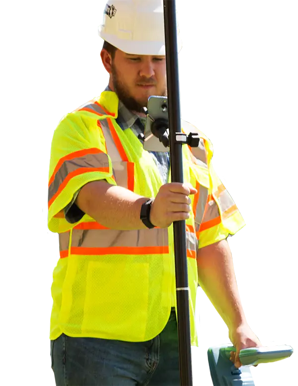
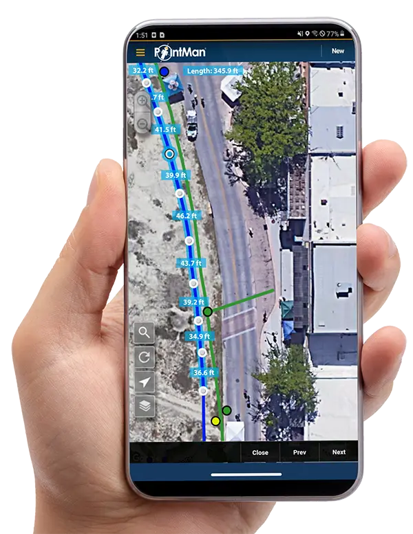
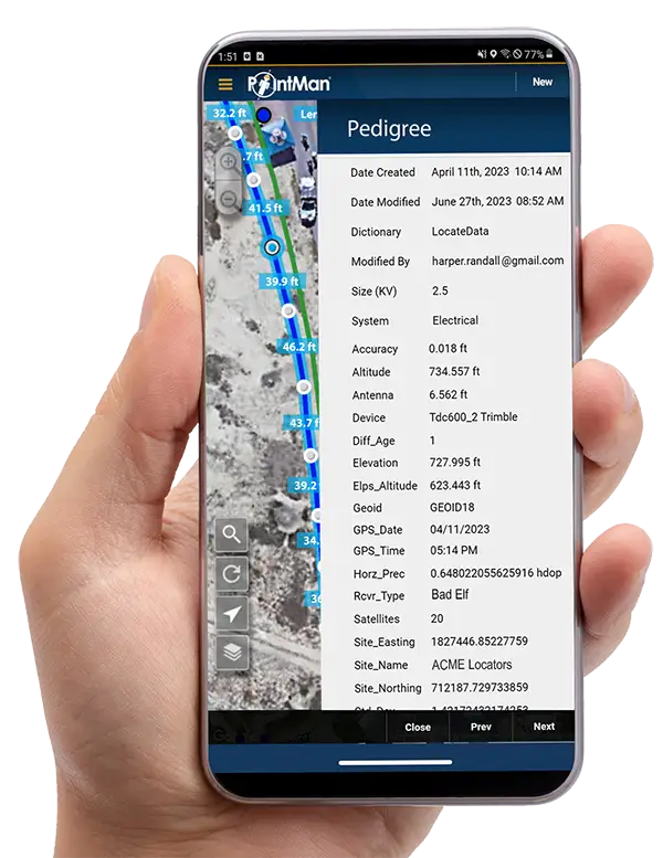
Integration Has Never Been Easier

Integrating a precision mapping solution with GPS receivers and electromagnetic cable and pipe locating devices has never been easier.  PointMan seamlessly integrates with Trimble, Juniper, Emlid, Bad Elf, Radiodetection, Vivax, Subsite, and 3M.

Forms, Sketches, and Much More!

  • Take Photos and Videos
  • Customizable Data Dictionary
  • Export Data – KML, KMZ, CSV, Shapefile, PDF, and GDB
  • Use Your Own Raster Imagery
  • View 811 Tickets
Our growing list of clients include Fortune 500 construction companies, utility owners, government agencies, engineering & surveying firms, and municipalities 

“CDOT finds incredible value in ProStar's geospatial asset management solution that is customizable, highly effective, and capable of high accuracy data capture.”

 – Rob Martindale
PLS Program Manager – Utilities/Railroads
Colorado Department of Transportation

“In our efforts to continue to be a Global leader and to satisfy our customer’s needs, we are eager to work with the leading technology providers that offer value-added software solutions. PointMan fits that model with a world-class utility mapping software that complements our solutions.”

– Matthew Wolf
President of ImpulseRadar USA, Inc.

“PointMan as it meets our high standards and offers unprecedented accuracy, aligns with our growth strategy, and best of all, is it is very easy to use and cost-effective.”

– Rhys Lambert
Gerneral Manager of Operations
Provac

“By adopting PointMan, we feel confident that we are implementing a world-class utility mapping solution that will provide us the ability to identify any utility infrastructure that is buried in the ground, which can be a serious concern in terms of worker and environmental safety as well as operational costs.”

– Philippe Gaultier
VP of Development Projects
IAMGOLD

“We adopted ProStar’s PointMan as it is a robust cloud and mobile mapping solution that provides us with a valuable toolset that will assist us in accomplishing our goals.”

– Chris Post
President, 2M Locating

“We have tried other solutions, but after months of testing, PointMan has proven to be the solution that best fits our needs in order to provide superior and consistent underground mapping services.”

– Chris Bower
Co-Founder and Director
Utility Mapping

“ProStar’s PointMan precision mapping solution means we can now locate, mark and map critical underground infrastructure in the proposed right-of-way for the fiber loop. "

– Skip McIntosh
Co-Founder
Landmark SUE Services

“We are excited to create this level of a partnership with ProStar. This collaboration will increase the value of our products by providing the ability to capture, record, display, and share precise location data with a simple to use mobile application.”

– Larry Fox
VP Marketing and Business Development, Bad Elf

“Simply put, we adopted PointMan because it makes our jobs easier, safer, and creates efficiencies for our clients and partners.”

– Frank Schill 
Pipeline Inspector
WSB

“Pairing PointMan with our Utiliguard 2 expands the ability and ease of our clients to provide better data quality to increase productivity and at the same time reduce cable strikes.

– Christopher Thompson
Product Marketing Manager
Subsite Electronics
Our growing list of clients include Fortune 500 construction companies, utility owners, government agencies, engineering & surveying firms, and municipalities 

“CDOT finds incredible value in ProStar's geospatial asset management solution that is customizable, highly effective, and capable of high accuracy data capture.”

 – Rob Martindale
PLS Program Manager - Utilities/Railroads
Colorado Department of Transportation

“In our efforts to continue to be a Global leader and to satisfy our customer’s needs, we are eager to work with the leading technology providers that offer value-added software solutions. PointMan fits that model with a world-class utility mapping software that complements our solutions.”

– Matthew Wolf
President of ImpulseRadar USA, Inc.

“PointMan as it meets our high standards and offers unprecedented accuracy, aligns with our growth strategy, and best of all, is it is very easy to use and cost-effective.”

– Rhys Lambert
Gerneral Manager of Operations
Provac

“By adopting PointMan, we feel confident that we are implementing a world-class utility mapping solution that will provide us the ability to identify any utility infrastructure that is buried in the ground, which can be a serious concern in terms of worker and environmental safety as well as operational costs.”

– Philippe Gaultier
VP of Development Projects
IAMGOLD

“We adopted ProStar’s PointMan as it is a robust cloud and mobile mapping solution that provides us with a valuable toolset that will assist us in accomplishing our goals.”

– Chris Post
President, 2M Locating

“We have tried other solutions, but after months of testing, PointMan has proven to be the solution that best fits our needs in order to provide superior and consistent underground mapping services.”

– Chris Bower
Co-Founder and Director
Utility Mapping

“ProStar’s PointMan precision mapping solution means we can now locate, mark and map critical underground infrastructure in the proposed right-of-way for the fiber loop. "

– Skip McIntosh
Co-Founder
Landmark SUE Services

“We are excited to create this level of a partnership with ProStar. This collaboration will increase the value of our products by providing the ability to capture, record, display, and share precise location data with a simple to use mobile application.”

– Larry Fox
VP Marketing and Business Development, Bad Elf

“Simply put, we adopted PointMan because it makes our jobs easier, safer, and creates efficiencies for our clients and partners.”

– Frank Schill 
Pipeline Inspector
WSB

“Pairing PointMan with our Utiliguard 2 expands the ability and ease of our clients to provide better data quality to increase productivity and at the same time reduce cable strikes.

– Christopher Thompson
Product Marketing Manager
Subsite Electronics

“PointMan delivers to KCI a more efficient workflow process, trusted data quality and precision, and it is also, by far, the easiest I have ever used when compared to any of the other major mobile GIS solutions on the market."

 – Joe Porter
National SUE Training and Quality Control Manager, KCI's SUE Team

“Even though we have invested hundreds of thousands to develop GIS mapping, getting the PointMan application provided us with an affordable, user-friendly tool to upload field data and develop a utility map.”

– John Avila
Administrator
The Village of Taos Ski Vally

“The locating industry is going digital, and it is important for us to use leading-edge utility mapping technologies. We believe that implementing PointMan into our company will allow us to offer our clients more timely and accurate asset location data.“

– Randy Palaniuk
General Manager
National Locators

“We pride ourselves on being an industry leader and providing world class subsurface utility engineering services. By adopting PointMan, we will continue to be a recognized leader and play a critical role in transforming the utility industry into the digital era.”

– Jerry Pugsley
SUE Manager, HKS

"We are using PointMan in combination with GPS equipment to provide that information in a way that it can be easily relocated in the field with an easy to use and affordable solution.”

– Colleen Boak
P.E., Senior Project Engineer
Water Works Engineers

"Federal and State regulations are becoming much stricter, and PointMan proved to be a very accurate, easy to use, and low-cost solution that checked all of our boxes.”

– Lucas Moore 
Region Manager - Rockies
Scout Energy

"We selected ProStar’s PointMan platform from our search for a GIS mapping platform that was easy to adopt, met our precision requirements for reference and locating needs, and flexibility for future GIS needs.”

– David Ellis 
Director of Network Services
Grinnell College

“There is nothing on the market even remotely close to PointMan, and I believe that there will be a larger number of other small municipalities in the U.S. that are also looking for a comprehensive mapping solution that is affordable and easy to implement and manage and in particular here in New Jersey based on state mandates.”

– Sandra Caceres  
Director of Public Works
Township of Aberdeen, NJ

“PointMan Pro is just a better way to do data collection and reduce risks and liabilities associated with the construction of our critical infrastructure projects.”

– Dustin Kelsey 
Project Manager
Kraemer

“Working with innovative and disruptive technologies like ProStar’s PointMan® is invaluable to the education of the engineering students at Louisiana Tech University.”

– Dr. John Matthews
TTC Director 
Louisiana Tech University

“We explored several options, and it became quite clear that PointMan provided exactly what we needed in order to help us transition into the new digital era and to remain an industry leader in providing utility damage prevention services.”

 – Antonio Guzman
COO, Safe2core

“We have been looking for an out-of-the-box and easy-to-use mapping solution to help us enhance our field data collection services, and PointMan checked all of the boxes.”

– Mark Sakach
Director of Operations 
RAVANAIR

“After exploring what solutions could meet our needs, it became quite apparent that PointMan was the best choice.”

– Alberto Aldana
City Engineer, Weslaco

"By adopting PointMan into our curriculum, we are confident that our students will be better prepared and highly sought after by companies in the underground facility locating industry.”

– Donald Richard
Vice President, LMI

“We adopted PointMan as our goal at CDI is to provide ‘best in class’ subsurface utility engineering survey services and to be recognized as a premiere service provider"

– Hayden Howard
Vice President/Co-Owner
CompassData

“PointMan provides us the ability to easily and accurately map existing infrastructure for both maintaining our large facility and making informed decisions about future construction projects."

– Cody Dunkin
Operations Manager
Tulsa Zoo

“We identified through our research and due diligence that ProStar would provide us with the most advanced and precise digital mapping solution."

– Brad Radichel
President
Condux International

“We are very excited with the vLoc3-RTK locator and its integration with ProStar’s PointMan.”

– Mark Drew
President
Vivax Metrotech

"Trimble and ProStar are changing the way construction companies, engineering and surveying firms as well as government transportation agencies capture, store and utilize utility infrastructure data."

– Stephanie Michaud
Strategic Marketing Manager
Trimble